Research
Arctic-Boreal rivers, wetlands, and lakes
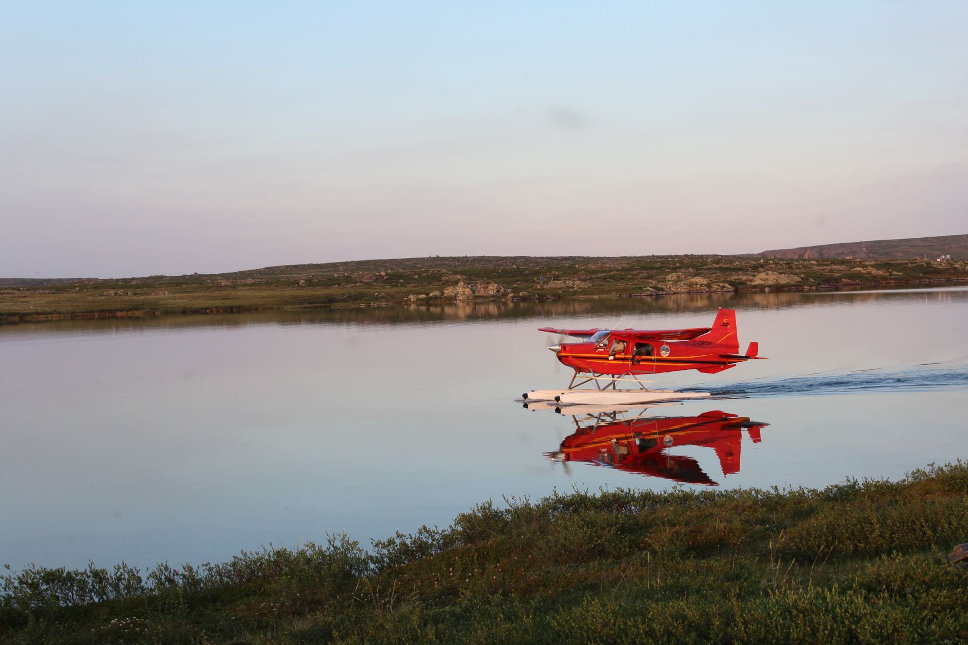
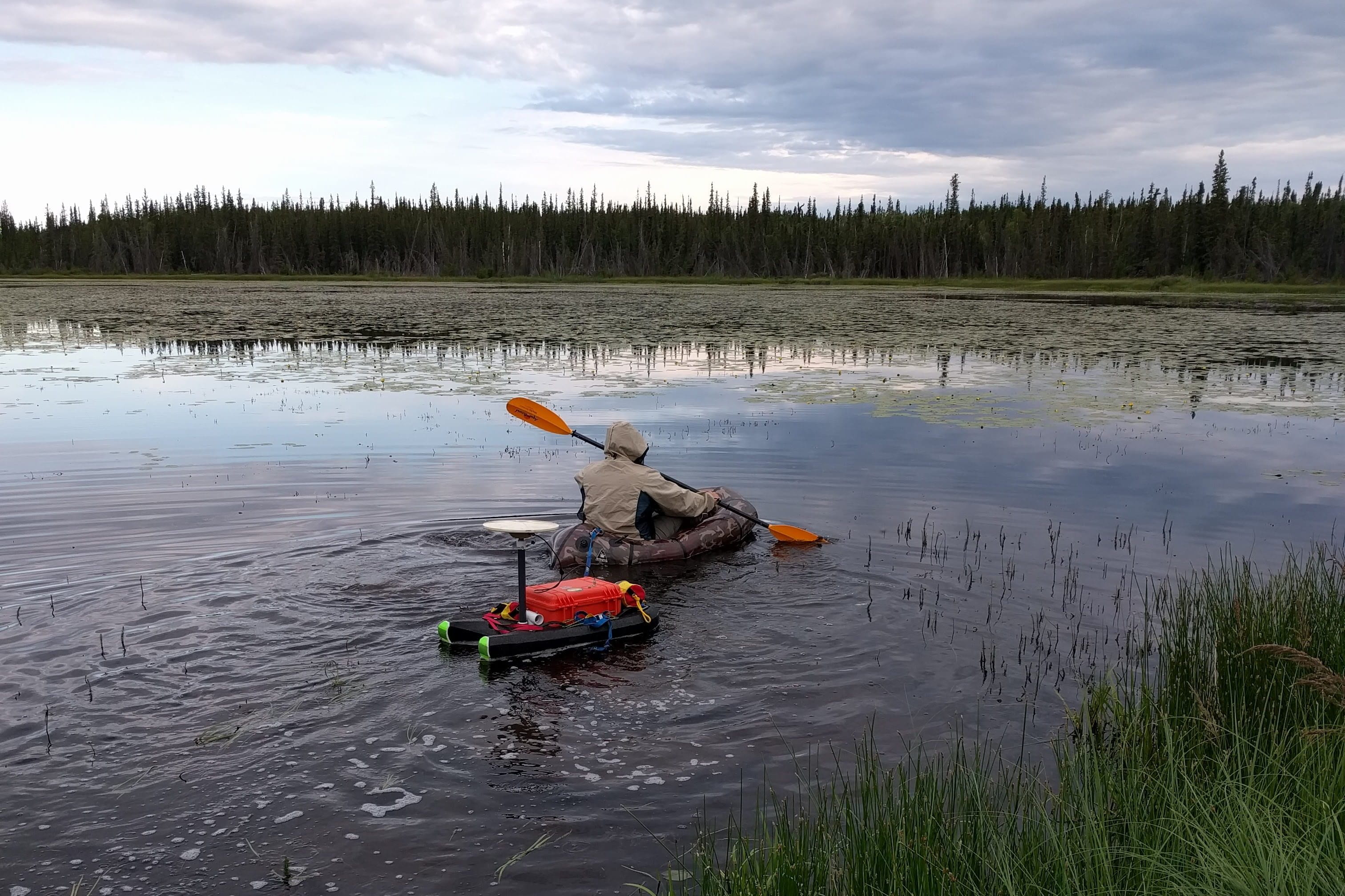
Remote North American Arctic and sub-Arctic landscapes contain the greatest abundance of surface water bodies on Earth. Despite their importance to global carbon and water cycles, ecosystems, and human activities most receive little to no study. Each spring the northern high latitudes undergo rapid transformations driven by sharply seasonal climate, melting snow and ice, and annual freeze/thaw cycles. Due to the fine spatial scale of most surface water processes, their associated dynamics are not readily observed from traditional single-sensor remote sensing approaches.
Our research blends remote sensing technologies with cutting-edge field campaigns to assess surface water dynamics across northern Canada and Alaska. Field methods include precision GPS surveys, hydrometric measurements, water quality, and greenhouse gas sampling.
Remote sensing technologies include satellites (e.g. Sentinel, Landsat, MODIS, ICESAT-2, SAR, and high-frequency Planet Cubesat images), drones, and targeted flight campaigns from the NASA Arctic-Boreal Vulnerability Experiment (https://above.nasa.gov).
Sample publications:
Zhang, Wang, C., Pavelsky, T.M., Kyzivat, E.D., Garcia-Tigreros, F., Podest, E., Yao, F., Yang, X., Zhang, S., Song, C., Langhorst, T., Dolan, W., Kurek, M.R., Harlan, M.E., Smith, L.C., Butman, D.E., Spencer, R.G.M., Gleason, C.J., Wickland, K.P., Striegl, R.G., Peters, D.L. (2023) Quantification of wetland vegetation communities features with airborne AVIRIS-NG, UAVSAR, and UAV LiDAR data in Peace-Athabasca Delta. Remote Sensing of Environment 294, 113646, https://doi.org/10.1016/j.rse.2023.113646
Wang, B., Smith, L. C., Gleason, C., Kyzivat, E.D., Fayne, J.V., Harlan, M.E., Langhorst, T., Feng, D., Eidam, E., Munoz, S., Davis, J., Pavelsky, T.M., Peters, D.L. (2023). Athabasca River avulsion underway in the Peace-Athabasca Delta, Canada. Water Resources Research, 59, e2022WR034114. https://doi.org/10.1029/2022WR034114
Kurek, M.R., Garcia-Tigreros, F., Wickland, K.P., Frey, K.E., Dornblaser, M.M., Striegl, R.G., Niles, S.F., McKenna, A.M., Aukes, P.J.K., Kyzivat, E.D., Wang, C., Pavelsky, T.M., Smith, L.C., Schiff, S.L., Butman, D., Spencer, R.G.M. (2023). Hydrologic and landscape controls on dissolved organic matter composition across western North American Arctic lakes. Global Biogeochemical Cycles, 37, e2022GB007495. https://doi.org/10.1029/2022GB007495
Lezine, E.M.D, Kyzivat, E.D., Smith, L.C. (2021) Super-Resolution Surface Water Mapping on the Canadian Shield Using Planet CubeSat Images and a Generative Adversarial Network, Canadian Journal of Remote Sensing, https://doi.org/10.1080/07038992.2021.1924646
Simpson, C.E., Arp, C.D., Sheng, Y., Carroll, M.L., Jones, B.M., Smith, L.C. (2021) Landsat derived bathymetry of lakes on the Arctic Coastal Plain of northern Alaska, Earth Syst. Sci. Data, 13, 1135–1150, https://doi.org/10.5194/essd-13-1135-2021
Fayne J.V., Smith L.C., Pitcher L.H, Kyzivat E.D., Cooley S.W., Cooper M.G., Denbina M., Chen A., Chen C., Pavelsky T.M. (2020) Airborne Observations of Arctic-Boreal Water Surface Elevation from AirSWOT Ka-Band InSAR and LVIS LiDAR. Environmental Research Letters 15(105005), https://doi.org/10.1088/1748-9326/abadcc
Kyzivat, E.D., Smith, L.C., Pitcher, L.H., Fayne, J.V., Cooley, S.W., Cooper, M.G., Topp, S.N., Langhorst, T., Harlan, M., Horvat, C., Gleason, C.J., Pavelsky, T.M. (2019) A high-resolution airborne color-infrared camera water mask for the NASA ABoVE campaign. Remote Sensing 11(18): 2163. https://doi.org/10.3390/rs11182163
*Pitcher, L.H, Pavelsky, T.M., Smith, L.C., Moller, D.K., Altenau, E.H., Allen, G.H., Lion, C., Butman, D., Cooley, S.W., Fayne, J., Bertram, M. (2019) AirSWOT InSAR mapping of surface water elevations and hydraulic gradients across the Yukon Flats Basin, Alaska. Water Resources Research, 55, 937– 953. https://doi.org/10.1029/2018WR023274
Cooley, S. W., Smith, L. C., Ryan, J. C., Pitcher, L. H., & Pavelsky, T. M. (2019). Arctic‐Boreal lake dynamics revealed using CubeSat imagery. Geophysical Research Letters, 46. https://doi.org/10.1029/2018GL081584
Cooley, S.W., Smith, L.C., Stepan, L., Mascaro, J. (2017) Tracking Dynamic Northern Surface Water Changes with High-Frequency Planet CubeSat Imagery. Remote Sensing 9(12), 1306, https://doi.org/10.3390/rs9121306

Yang, K., Smith, L.C., Fettweis, X, Gleason, C.J., Lu, Y., Li, M. (2019) Surface meltwater runoff on the Greenland ice sheet estimated from remotely sensed supraglacial lake infilling rate (2019). Remote Sensing of Environment 234, 111459, https://doi.org/10.1016/j.rse.2019.111459
Pitcher, L.H., and Smith, L.C. (2019) Supraglacial Streams and Rivers. Annual Review of Earth and Planetary Sciences 47:1, 421-452, https://doi.org/10.1146/annurev-earth-053018-060212
Ryan, J.C., Smith, L.C., Van As, D., Cooley, S.W., Cooper, M.G., Pitcher, L.H, Hubbard, A. (2019) Greenland Ice Sheet surface melt amplified by snowline migration and bare ice exposure Science Advances 5(3), eaav3738, https://doi.org/10.1126/sciadv.aav3738
Cooper, M. G., Smith, L. C., Rennermalm, A. K., Miege C., Pitcher, L. H, Ryan, J. C., Yang, K., and Cooley, S. (2018), Near surface meltwater storage in low-density bare ice of the Greenland ice sheet ablation zone, The Cryosphere, 12, 955-970, https://doi.org/10.5194/tc-12-955-2018
Smith, L.C., Yang, K., Pitcher, L.H, Overstreet, B.T., Chu, V.W., Rennermalm, Å.K., Ryan, J.C., Cooper, M.G., Gleason, C.J., Tedesco, M., Jeyaratnam, J., van As, D. van den Broeke, M.R., van de Berg, W.J., Noël, B., Langen, P.I, Cullather, R.I., Zhao, B., Willis, M.J., Hubbard, A., Box, J.E., Jenner, B.A., Behar, A.E. (2017). Direct measurements of meltwater runoff on the Greenland Ice Sheet surface, Proceedings of the National Academy of Sciences (PNAS) 114 (50) E10622-E10631. https://doi.org/10.1073/pnas.1707743114
Yang, K., and Smith, L.C. (2016), Internally drained catchments dominate supraglacial hydrology of the southwest Greenland Ice Sheet, J. Geophysical Res. Earth Surf., 121, https://doi.org/10.1002/2016JF003927
Smith, L.C., Chu, V.W., Yang, K., Gleason, C.J., Pitcher, L.H., Rennermalm, A.K., Legleiter, C.J., Behar, A.E., Overstreet, B.T., Moustafa, S.E., Tedesco, M., Forster, R.R., LeWinter, A.L., Finnegan, D.C., Sheng, Y., Balog, J. (2015), Efficient meltwater drainage through supraglacial streams and rivers on the southwest Greenland ice sheet, Proc. Nat. Acad. Sci. (PNAS), 112(4), 1001-1006. https://doi.org/10.1073/pnas.1413024112
Meltwater runoff from the Greenland Ice Sheet
Meltwater runoff from the Greenland Ice Sheet is a major contributor to global sea level rise. Our team pioneered the use of extreme field campaigns and remote sensing to quantify the production and transport of meltwater flowing across its surface. These measurements provide rare real-world datasets to test and improve the world’s leading regional climate models, which are used to forecast Greenland’s future meltwater contributions to sea level rise.
Our work also seeks to advance basic scientific understanding of the most melt-intensive area of the ice sheet where 90% of runoff is generated – the bare-ice ablations zone – which has historically received light study relative to other areas of the ice sheet.
Sample publications:
Zhang, W., Yang, K., Smith, L.C. Wang Y., van As, D., Noël, B., Lu, Y., Liu, J. (2023) Pan-Greenland mapping of supraglacial rivers, lakes, and water-filled crevasses in a cool summer (2018) and a warm summer (2019). Remote Sensing of Environment 297, 113781, https://doi.org/10.1016/j.rse.2023.113781
Goldstein, S.N., Ryan, J.C., How, P.R., Esenther, S.E., Pitcher, L.H, LeWinter, A.L., Overstreet, B.T., Kyzivat, E.D., Fayne, J.V., Smith, L.C. (2023), Proglacial river stage derived from georectified time-lapse camera images, Inglefield Land, Northwest Greenland. Front. Earth Sci. 11:960363. https://doi.org/10.3389/feart.2023.960363
Smith, L.C., Andrews, L.C., Pitcher, L.H, Overstreet, B.T., Rennermalm, Å.K., Cooper, M.G., Cooley, S.W., Ryan, J.C., Miège, C., Kershner, C., Simpson, C.E. (2021) Supraglacial river forcing of subglacial water storage and diurnal ice sheet motion. Geophysical Research Letters, 48, e2020GL091418. . https://doi.org/10.1029/2020GL091418
Pitcher, L.H., Smith, L.C., Gleason, C.J., Miege, C., Ryan, J.C., Hagedorn, B., van As, D., Chu, W., Forster, R.R. (2020) Direct observation of wintertime meltwater drainage from the Greenland Ice Sheet, Geophysical Research Letters, e2019GL086521, https://doi.org/10.1029/2019GL086521
Yang, K., Sommers, A., Andrews, L.C., Smith, L.C., Lu, X., Fettweis, X., and Li, M. (2020) Intercomparison of surface meltwater routing models for the Greenland ice sheet and influence on subglacial effective pressures, The Cryosphere, 14, 3349–3365, https://doi.org/10.5194/tc-14-3349-2020
Cooper, M.G., Smith, L.C. (2019) Satellite Remote Sensing of the Greenland Ice Sheet Ablation Zone: A Review. Remote Sensing 11, 2405. https://doi.org/10.3390/rs11202405
Smith, L.C., Yang, K., Pitcher, L.H, Overstreet, B.T., Chu, V.W., Rennermalm, Å.K., Ryan, J.C., Cooper, M.G., Gleason, C.J., Tedesco, M., Jeyaratnam, J., van As, D. van den Broeke, M.R., van de Berg, W.J., Noël, B., Langen, P.I, Cullather, R.I., Zhao, B., Willis, M.J., Hubbard, A., Box, J.E., Jenner, B.A., Behar, A.E. (2017). Direct measurements of meltwater runoff on the Greenland Ice Sheet surface, Proceedings of the National Academy of Sciences (PNAS) 114 (50) E10622-E10631. https://doi.org/10.1073/pnas.1707743114
Three-dimensional remote sensing of surface water
Surface hydrology studies traditionally use remote sensing to map the extents of water bodies and their areal changes over time. However, advancing satellite technology now enables estimation of water surface elevations, river discharge, and their variations over space and time.
These technologies include lidar and interferometric synthetic aperture radar (InSAR) being deployed on airborne and satellite platforms. Our lab is deeply involved with the scientific use of water surface elevations, discharge retrievals, and storage changes using AirSWOT, ICESAT-2, and forthcoming NASA/CNES/CSA SWOT (Surface Water and Ocean Topography) satellite mission.
Sample publications:
Fayne J.V., Smith L.C. (2023) How Does Wind Influence Near-Nadir and Low-Incidence Ka-Band Radar Backscatter and Coherence from Small Inland Water Bodies? Remote Sensing, 15(13), 3361. https://doi.org/10.3390/rs15133361
Kyzivat, E.D., Smith, L.C. (2023) Contemporary and historical detection of small lakes using super resolution Landsat imagery: promise and peril, GIScience & Remote Sensing, 60:1, 2207288, https://doi.org/10.1080/15481603.2023.2207288
LOBER, C., FAYNE, J.V., HASHEMI, H., SMITH, L.C. (2023). Bias Correction of 20 years of IMERG Satellite Precipitation Data over Canada and Alaska. J. Hydrology-Regional Studies 47, 101386, https://doi.org/10.1016/j.ejrh.2023.101386
Cooley, S.W., Ryan, J.C., Smith, L.C. (2021) Human alteration of global surface water storage variability. Nature 591, 78–81 (2021). https://doi.org/10.1038/s41586-021-03262-3
Fayne J.V., Smith L.C., Pitcher L.H, Kyzivat E.D., Cooley S.W., Cooper M.G., Denbina M., Chen A., Chen C., Pavelsky T.M. (2020) Airborne Observations of Arctic-Boreal Water Surface Elevation from AirSWOT Ka-Band InSAR and LVIS LiDAR. Environmental Research Letters 15(105005), https://doi.org/10.1088/1748-9326/abadcc
Ryan, J.C., Smith, L.C., Cooley, S.W., Pitcher, L. H, Pavelsky, T.M. (2020) Global characterization of inland water reservoirs using ICESat-2 altimetry and climate reanalysis. Geophysical Research Letters 47(17), e2020GL088543, https://doi.org/10.1029/2020GL088543
Pitcher, L.H., Smith, L.C., Cooley, S.W., Zaino, A., Carlson, R., Pettit, J., Gleason, C.J., Minear, T., Fayne, J.V., Harlan, M.E., Langhorst, T., Topp, S.N., Dolan, W., Kyzivat, E.D., Pietroniro, A., Yang, D., Carter, T., Onclin, C., Hosseini, N., Moreira, D., Berge-Nguyen, M., Cretaux, J.-F., Pavelsky, T.M. (2020) Advancing field-based GNSS surveying for validation of remotely sensed water surface elevation products. Frontiers in Earth Science 8(278), https://doi.org/10.3389/feart.2020.00278

Pitcher, L.H, Pavelsky, T.M., Smith, L.C., Moller, D.K., Altenau, E.H., Allen, G.H., Lion, C., Butman, D., Cooley, S.W., Fayne, J., Bertram, M. (2019) AirSWOT InSAR mapping of surface water elevations and hydraulic gradients across the Yukon Flats Basin, Alaska. Water Resources Research, 55, 937– 953. https://doi.org/10.1029/2018WR023274
Durand, M., Gleason, C.J., Garambois, P.A., Bjerklie, D., Smith, L. C., Roux, H., Rodriguez, E., Bates, P. D., Pavelsky, T. M., Monnier, J., Chen, X., Di Baldassarre, G., Fiset, J.-M., Flipo, N., Frasson, R. P. d. M., Fulton, J., Goutal, N., Hossain, F., Humphries, E., Minear, J.T., Mukolwe, M.M., Neal, J.C., Ricci, S., Sanders, B.F., Schumann, G., Schubert, J.E., Vilmin, L. (2016), An intercomparison of remote sensing river discharge estimation algorithms from measurements of river height, width, and slope, Water Resources Research, 52, 4527–4549, https://doi.org/10.1002/2015WR018434.
Gleason, C.J., Smith, L.C., Lee, J. (2014) Retrieval of river discharge solely from satellite imagery and at-many-stations hydraulic geometry: Sensitivity to river form and optimization parameters. Water Resources Research, 50(12), 9604-9619, https://doi.org/10.1002/2014WR016109
Gleason, C.J., and Smith, L.C. (2014) Toward global mapping of river discharge using satellite images and at-many-stations hydraulic geometry. Proc. Nat. Acad. Sci (PNAS), 111 (13), 4788-4791 https://doi.org/10.1073/pnas.1317606111
Gleason, C.J., and Smith, L.C. (2014) Toward global mapping of river discharge using satellite images and at-many-stations hydraulic geometry. Proc. Nat. Acad. Sci (PNAS), 111 (13), 4788-4791 https://doi.org/10.1073/pnas.1317606111
SMITH, L.C., AND T.M. PAVELSKY (2009) Remote sensing of volumetric storage changes in lakes, Earth Surface Processes and Landforms 34, 1353-1358. https://doi.org/10.1002/esp.1822
SMITH, L.C., AND T.M. PAVELSKY (2008) Estimation of river discharge, propagation speed, and hydraulic geometry from space: Lena River, Siberia. Water Resources Research 44, W03427 https://doi.org/10.1029/2007WR006133
Bennett, M.M., and Smith, L.C. (2017), Using multitemporal night-time lights data to compare regional development in Russia and China, 1992–2012, International Journal of Remote Sensing, https://doi.org/10.1080/01431161.2017.1312035
Stephenson, S. R. and Smith, L. C. (2015), Influence of climate model variability on projected Arctic shipping futures. Earth’s Future, 3, 331–343, https://doi.org/10.1002/2015EF000317
Blom, A., Brady, A.-M., Brigham, L., Conley, H., Daly, M., Hamilton, N., Hansen, Rúni M., Harper, S., Henriksen, S., Kamikawa, Y., Kortunov, A.V., Minerd, S., Pickard, A., Roosevelt, T, Smith, L.C., Støre, J.-G., Tae-Yul, C., Treadwell, M., Tschudi, F.H., Volynets, A., Winther, J.-G., Yuhang, W (2015) Arctic Investment Protocol. Technical Report. World Economic Forum, Geneva, Switzerland. http://www3.weforum.org/docs/WEF_Arctic_Investment_Protocol.pdf
Stephenson, S.R., Brigham, L.W., Smith, L.C., (2014), Marine accessibility along Russia’s Northern Sea Route. Polar Geography, 37(2), 111-133, https://doi.org/10.1080/1088937X.2013.845859
Smith, L.C., and S.R. Stephenson, New Arctic shipping routes navigable by midcentury (2013) Proc. Nat. Acad. Sci. (PNAS) 110(13) E1191–E1195, https://doi.org/10.1073/pnas.1214212110
Stephenson, S.R., Smith, L.C., Brigham, L.W., and J.A. Agnew (2013) Projected 21st-century changes to Arctic marine access, Climatic Change 118(3), 885-899, https://doi.org/10.1007/s10584-012-0685-0
STEPHENSON, S.R., SMITH, L.C., AND J.A. AGNEW (2011) Divergent long-term trajectories of human access to the Arctic, Nature Climate Change 1, 156–160, https://doi.org/10.1038/nclimate112
SMITH, L.C., Agents of Change in the New North (2011) Eurasian Geography and Economics 52(1), 30–55, https://doi.org/10.2747/1539-7216.52.1.30
Sustainable Arctic policy and development
Climatic and physical changes now underway in the northern high latitudes are colliding with economic, cultural, political, and historical legacies of the region. The Arctic, in particular, is home to some 4 million people and >$230B economy, long under the jurisdiction of eight sovereign nations (Russia, Finland, Norway, Sweden, Iceland, Greenland/Denmark, Canada and the United States) and, more recently and to varying degrees, indigenous home-rule agreements.
Offshore, Arctic coastal waters fall within national Exclusive Economic Zones (EEZs) with further seafloor sovereignty extensions available through Article 76 of the United Nations Convention on the Law of the Sea (UNCLOS). Declining sea ice cover has raised widespread interest in the region, leading to numerous misperceptions.
Our research therefore seeks to demystify the Arctic through study of societal, as well as geophysical changes, in this iconic yet fascinatingly complex region.
Sample publications:
Steiro, V.D., Ryan, J.C., Cooley, S.W., Smith, L.C., Dale, B., Lynch, A.H., Veland, S. (2021) Changes in sea ice travel conditions in Uummannaq Fjord, Greenland (1985–2019) assessed through remote sensing and transportation accessibility modeling, Polar Geography, https://doi.org/10.1080/1088937X.2021.1938271
Popelka, S.J., Smith, L.C. (2020) Rivers as political borders: a new subnational geospatial dataset. Water Policy 22(3): 293–312, https://doi.org/10.2166/wp.2020.041
Cooley, S.W., Ryan, J.C., Smith, L.C., Horvat, C., Pearson, B., Lynch A.H. (2020) Coldest Canadian Arctic communities face greatest reductions in shorefast sea ice. Nature Climate Change, https://doi.org/10.1038/s41558-020-0757-5
Bennett, M.M., and Smith, L.C. (2017), Advances in using multitemporal night-time lights satellite imagery to detect, estimate, and monitor socioeconomic dynamics. Remote Sensing of Environment 192, 176-197, https://dx.doi.org/10.1016/j.rse.2017.01
Our Office
Northern Change Research Laboratory
Institute at Brown for Environment and Society (IBES)
Brown University
Box 1951
85 Waterman Street
Providence, RI 02912
Contact Us
(401) 863-3449
northernchange@brown.edu